Michelle had class and a haircut scheduled for today, so I decided to take the “Taipei Metro’s Guide to Hiking and Cycling” and try to locate a good day hike from an MRT station.
Last night as we were coming home, very late, from Danshui, Irene noticed that the outline of Taipei 101 looked blurred and obscured by clouds. I told her it must be an illusion because there couldn’t possibly be clouds. There weren’t, it was pollution. Yesterday’s clear weather must have had an inversion layer and collected all the pollution. This morning when I got out, the air was disgusting.
Taipei is very proud that they’ve labeled their trails with signs in both Chinese and English, and I’m not complaining about that.
They’ve also published a guide to tell you which train stations have these signs pointing you at trails. The guide is only in Chinese and Japanese.
Nonetheless, it was with a sense of learning and adventure that I sat down this morning, comparing the hiking guide to a MRT map with both English and Chinese station names, studying the time estimates in the hiking guide for the length of the hike, rejecting those that said “Bus” in Japanese as the first step.
Finally, I settled on what looked to be a fairly long, but easy to follow trail looping from Houshanpi Station up to Tiger, Lion, Elephant and some other cat mountain. The Elephant Mountain trail is often mentioned in articles on day hikes from Taipei, although when I started, I didn’t realize that’s where I was going.
When I arrived at the station, I easily found the first sign (in fact, a the time, I’d forgotten that Taipei had placed the signs). The sign pointed in a consistent direction with the map. The map; however, seemed rather illogical. Rather than taking a straight street in an almost direct line with the trailhead, it turned away at 45 degrees, then sharply angled back to a line perpendicular to the trail.
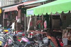
The only conclusion I can draw is that the path is designed to take you through a street market area, perhaps to help drive business through the market. Heaven knows how many times I’ve started to take a hike and I say to myself, “I need to buy some raw meats, fish and vegetables for my hike!”
I never saw another Taipei trail marker until I actually reached the entrance street. If I’d followed the one sign I saw at the station, I’d have never found the trailhead.

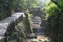
When I reached the start, the trail was clearly marked and quite nice. One nice thing about some trails in Taiwan, they place distance markers facing both directions on the trail, so if you pass a 100m mark, and look the other way and see a 550m mark, you know the trail is 640m long and you’ve got 550m to go.
What didn’t make sense was that the trail looked a lot longer than that. (Actually, I don’t remember the numbers, but there were less than 1/2 a kilometer) Still, I was there to see what I could see.
What happened was that when I reached the “end” of the first trail, really the only place to go was the beginning of the next trail. After a while, the distance markers become useless because the reset at the beginning of each new trail.
At one point the “trail” became a mountain road, but after walking down it for a while, with doubts in my mind that I was still on the right path, I came to another Taipei hiking sign indicating this was the right way. I believe I eventually managed to reach all four animal mountains. A couple of them were difficult to reach.
Many times as I walked along the road, there were trails leading up and down off to the side. Some were unmarked completely, others had simple Chinese signs. Every once in a while, I would feel like I should be going on one of those and would end up at someone’s shack, or cultivated field. I’d always return to the road and continue on my way.
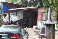
At one point, I came to a peak in the road and there was an open air restaurant, with a woman belting out karaoke. I’d swear it was the exact same woman and exact same song as I saw at Chiang Kai-Shek Memorial and in the town of Puli. There really ought to be a law against that outdoors.
Eventually, I concluded I was lost. I came to a Taipei sign pointing down the mountain (stairs, lots of stairs) indicating a temple was there. I decided to gamble and headed towards it, hoping that it would have a parking lot and a road that was a lot closer to the bottom of the mountain.
When I got there, it was as I’d hoped, and I finally broke out the GPS, which was low on batteries, and checked my distance and bearing to the train station. I was about 1.5 miles away as the crow flies, but at least it was downhill. I reached the city streets and would my way around until the GPS lead me unerring back to the entrance of the train station.
This part of town has lighter traffic in the streets, but the sidewalks are completely covered over with overhangs and stores extending out to the street. To keep the GPS signal, I finally just walked in the middle of the road and the traffic be damned. They went around me without a second thought.
That’s the attitude you have to adopt on the streets here: you just drive around the other people and not get mad. If they didn’t do that, there’d be a 50% reduction in drivers every day as they killed each other off in road rage battles.