This article of a three-part series. Part One detailed my history with GPS units over the last 12 years.
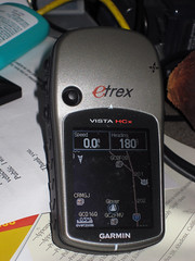
This part picks up with my selection criteria and impressions of the Garmin Vista HCx GPS.
Being a computer-oriented person, my first “requirement†in a GPS was convenient data access to a computer. That was true years ago when the process was rudimentary, and it is even more true in this age of Google Earth and travel routing GPS systems.
My list of requirements:
After much research, I zeroed in on the Garmin eTrex Vista HCx model. Garmin makes several lines of GPS, but I opted to stay with the eTrex models based on familiarity and, among the different lines, the available options are generally the same, with a few exceptions. Within the eTrex line there is a plethora of models these days, ranging down to the basic model that my dad has to the high-end Vista HCx.
Since I got it, three weeks ago, I’ve also purchased a number of “accessoriesâ€, including mounting hardware, data card, maps, etc. I’ll try to address them in the next article.
Accuracy
It would be hard to argue otherwise that a GPS’s utility lives and dies by its accuracy. So far, this unit’s accuracy has been exemplary. We can try to shoehorn in Heisenberg’s Principal of Uncertainty and argue in a somewhat roundabout way that I can’t be certain about the accuracy because I’ve can’t be certain of the accuracy of the original measurement of the point I’m trying to compare measurement to.
In short, how do I know for sure that the GPS is leading me to the actual spot I told it to?
The best I can do is try to assess how I’ll use the GPS, and go from there. How will I use the GPS? Largely with Google Earth, so the accuracy has to tally with Google Earth.
I’ve taken several clearly identifiable points in the Google Earth satellite imagery, such as the basketball goal in my father’s backyard and marked the waypoints. I’ve transferred that waypoint to the GPS and navigated to the waypoint. Under those conditions, the accuracy has been consistently approximately 10 feet. (Garmin literature indicates 9′ accuracy with error-correction turned on. My tests indicate there’s no reason to dispute that.)
My second series of tests involved going to areas with a visible landmark, such as an isolated tree in a park, and snapping a waypoint using the GPS. I then transferred that waypoint into Google Earth and compared the placement with the actual landmark. Again, the point is almost always off by approximately 10′.
Note, I said “off†by 10′, not “within†10′. In every test, the waypoint has missed the landmark by 8-10′ as measured by Google Earth’s measuring tool.
The third way I tested it was to snap a waypoint at a known landmark, then, on another day, attempt to return to it.
I wasn’t sure what to expect with this test. Would the inherent error is the taking and the reading of the measurements cause the error to compound each other? Cancel each other out? or both? Answer: Both. The error factor was a lot more variable, and stretched, on one occasion, to nearly 20 feet. Generally the error was in the 5-15′ range.
That indicates to me that the error factor of a GPS has to do with time-dependent factors, rather than the algorithms used to compute location. If it were the algorithms, I would except finding this particular type of waypoint would be the most accurate, since the algorithm would “re-create†the same error at the same location.
Summary of accuracy: I’m completely satisfied that the unit consistently works to the manufacturers specifications.
Reception
So far, I’ve had extremely fast acquisition of satellites, outdoors and in. The only exception is at my office, which the 4-storey metal-framed building blocks practically ever kind of signal.
Operation & Controls
The eTrex Vista models evolved from the earlier eTrex model, which is what my father owns. The eTrex was originally designed for left-handed operation. The literature said that this was so that your right hand was free for carrying walking sticks or whatever. We’re both right-handers, and almost never use the eTrex in the left hand.
The Vista, on the other hand, although I didn’t notice any explicit mention of it in the manual (such as it was) follows the left-handed convention, although the buttons are different from the eTrex because of the more complicated menuing system. The unit can still be operated in the right hand, but the additional thumb control on the front is clearly positioned for the left-hand thumb. Access from the right hand requires your thumb to cross the screen, or shifting the GPS to an awkward position.
This has been giving me a little trouble since I’m used to holding the eTrex in my right hand and prefer it that way under most conditions.
Apart from the thumb control on on the front, the other controls are on the side of the unit, keeping your fingers away from the screen.
The top two controls on the left work the zoom, up and down. Below them is a “menu†button, which serves roughly three functions. First, press it once on any screen, and the menu for that screen pops up. Press the button twice (or press it again when in a screen menu) and the system main menu screen is brought up, which may save you a long trip through the screens. Finally, press and hold the button, and you are taken directly to the “find†screen.
On the right side, the top button is the “page†button, and also the cancel that dismisses menus or other dialogs. This button, when held in for a while also turns on and off the electronic compass.
The lower button on the right is the power button and also the button for activating the backlight.
On the front is the thumb control, which navigated through menus and when pressed, is the “Enter†key. I have the most problems with the thumb control. It navigates fine, but the Enter press has to be straight down. If you press at any angle, it seems to cancel what you’re doing. Big, clumsy thumbs need not apply.
Menus/screens
The eTrex Vista HCx is operated via a series of screens, such as the main menu, the compass, the map screen, etc. You cycle through them using the page button. The screens that you see, and the order they appear in are configurable. If you have too many screens, it can become a chore to “cycle around†to the screens you normally use. From the main menu, you can choose to go directly to any screen that you don’t have in rotation. If you do have that screen configured to be in the rotation of pages, it doesn’t appear on the main menu anymore. I think this is a flaw.
When you manually select a screen from the menu, if you then hit the page key to see another commonly-used screen, you can’t get back to the first screen without going back to the main menu and selecting it from there again. I haven’t (yet) come to the right customization of screens so that I don’t feel inconvenienced from time to time. Still, it does have a lot of available screens, many of which I never care to see, such as the one for timing a high-altitude parachute jump.
Briefly, I’ll touch on several of the screens that I use most commonly.
The Main Menu – Always available. Lists all the functions you don’t have configured to be screens. Setup and Find are also on this menu.
Compass – The compass is, not too surprisingly, a graphic representation of a compass. The compass heading is derived principally from the navigation data as you move. When you stop, GPS compasses become confused. the Vista HCx model includes and electronic compass for use in these times. Because it drains power, the compass doesn’t activate until you’ve been motionless for a certain period of time. You can also deactivate it completely if you don’t want to come on when you stop moving. If you’re navigating to a point, the compass also has a pointer to show which way you should be going.
There are also some data displayed on the compass screen, which I’ll get to when I discuss the Trip Computer
Trip Computer – The Trip Computer is basically the “Geek screen.†It’s a data read-out display of 8 different facets of your navigation. You get to choose which ones from a long list. Some examples of the types of data: elevation, speed, course, odometer, distance to next destination, distance to final destination, current ETA as destination, and a whole raft of others. These fields are configurable, and you can also switch to a “big numbers†mode for people with difficulty reading the small screen. You only get three data fields in big numbers mode.
The ability to pick and choose you data displays is also available on other screens, such as the Compass, the Highway display and the Map. On those screens, you have fewer available data fields, but you have the same selection pool to choose from. I like this customization, and I’m still experimenting with the “best mix.†I tend to like different information depending on how I’m navigating and, like the choice of screens, I haven’t quite found what works best for me yet.
Map – The map represents a top-down view of where you are, relative to other waypoints and map points in the system. It also shows a breadcrumb trail of where you’ve been, and a course line to where you’re going.
Out of the box, the Vista HCx only has a North American base map which includes major highways and interstates, plus some rough waypoints for locating major cities. This unit is compatible with Garmin’s MapSource products, but in the interest of keeping this review a bit shorter, I’ll save reviewing the GPS w/maps for a later post.
Extra Features
The various lines of Garmin GPSes have a variety of different “levelsâ€, for example, the “H†in HCx is for High-Sensitivity, which means it is a WAAS-enabled unit. (WAAS is a air navigation aid designed to augment GPS accuracy), The “C†is for Color screen, and the “x†designates that the unit accepts MicroSD data cards.
The eTrex line, in addition to the basic and the Vista models, also includes the Summit, the Legend and the Venture. It’s not important to differentiate them here, but the features that differentiate the Vista models are the electronic compass and the barometric altimeter. Without those features, the eTrex Legend is virtually identical, with a list cost of over $50 less.
Both the altimeter and the compass work, but need calibration, particularly the altimeter which is subject to changes in air pressure associated with storm fronts. GPS-calculated altitudes are notoriously inaccurate, and if you want accurate altitude info, the extra cost for the altimeter may be justified. However, if you load topographical maps into the GPS, the waypoint marking process will use the more accurate data from the MAP to set the altitude. (Or so I’m told.) This might be an alternative for some people rather than the altimeter option.
Data Interface
Unlike many older Garmin units (and even some current ones), the Vista models use a USB interface, rather than a proprietary serial cable. Not only does that make it easier to connect to modern computers, but USB supplies power to the GPS, conserving battery life.
To get the data to and from your computer, you need software, and since I’m exclusively a Mac user, that can present problems since it’s still standard practice for device manufacturers to concentrate on Windows users first, if not exclusively.
Garmin is at least working on OSX compatibility, and they provide several downloadable OSX-based utilities, such as a firmware updater and map and Point of Interest loaders. Also, there’s a web-based waypoint loader, used at places like geocaching.com or motionbased.com that allow you to interact with web sites and up and download waypoints. I’ve used both the firmware updater and the online transfer utilities and both worked flawlessly.
What I really need is import and export from Google Earth. For $20 you can upgrade to Google Earth Plus, which lets you connect your GPS to Google Earth, for importing and real-time tracking of your position, but it doesn’t support plotting waypoints in Google Earth and sending them to your GPS. That makes it next to worthless for planning any kind of excursion.
What I found was a program called GPSBabel+ which not only converts to and from most GPS-like formats, but can import/export directly to/from the Garmin GPS.
With these free resources, the Vista HCx works well with a Mac, save for using maps, which is awkward and requires some expensive “extra†software. Which I’ll describe in the MapSource post.
Misc
When my dad got his first Garmin GPS, it included a big manual, and even a video on using the GPS. When he got his eTrex, it at least included a helpful manual. The manual for the Vista HCx really assumes you already know all you need to know about GPSes, and does a poor job of explaining the functions. The Garmin website FAQs and such are also nearly useless.
I hope this isn’t intentional to drive sales of training videos or books. They really need to improve their documentation.
The color screen is a bit difficult to read in daylight, and I find myself turning on the backlight even during the day, which ought to be unnecessary.
Conclusion
The Vista HCx is an impressive all-around, hand-held GPS.

“Garmin eTrex Vista HCx Color High-Sensitivity Mapping Handheld GPS†(Garmin)
Technorati Tags: GPS, Review, Technology
What you mean when you say that the GPS-calculated altitudes are notoriously inaccurate? Yo gave excellent examples about how you did to calculate the GPS accuracy with google earth, but not about this, how you determined that the GPS altitude shown was innacurate? I’m waiting my VISTA HCX next monday-tuesday, I had understood that the satellitte altitude data nowadays was quite precise, even if you have not a barometer. Greetings, and thanks for writing this review, it was very useful.
What you mean when you say that the GPS-calculated altitudes are notoriously inaccurate? Yo gave excellent examples about how you did to calculate the GPS accuracy with google earth, but not about this, how you determined that the GPS altitude shown was innacurate? I’m waiting my VISTA HCX next monday-tuesday, I had understood that the satellitte altitude data nowadays was quite precise, even if you have not a barometer. Greetings, and thanks for writing this review, it was very useful.
I did not have a good way to test altitude data.
It was still my understanding that the vertical accuracy of GPS technology still has a much greater margin for error than the horizontal accuracy.
I suppose it stands to reason that as they’ve improved horizontal accuracy, vertical accuracy has most likely improved as well.
However, from reading posts on the forums and what I pick up from the product literature, it seems that if you want accuracy, you still need a barometric altimeter, hence that option on the Vista HCx.
Also, I understand, but have not tested, that when you have certain map data loaded, certainly the TOPOs and possibly the City Navigator products, those maps include Digital Elevation Model (DEM) data, and the Garmin will use the DEM data to record altitude based on the horizontal location fix rather than the internal calculated altitude.
That would also tend to infer that the altitude calculation is less-than-optimal.
It is unclear to me if the Vista also gave precedence to the DEM data over the barometric readings.
A couple extra notes:
(1) I mention to appalling manual provided with the Vista HCx. It turns out I’m not the first to notice that. I was pointed to the manual for the now-discontinued eTrex VistaC, which you can find here – at least for now
It’s a very similar GPS, but the manual is actually useful. Shame on Garmin for not just updating this manual – it’s not like they had to write an all new one.
(2) There’s more information about the mapping products and software for this unit at my blog post, here.
Thanks for the link to the manual. I got a HCX for Christmas and have struggled to use it with the poor information provided by Garmin.
Rob
Thanks for the link to the manual. I got a HCX for Christmas and have struggled to use it with the poor information provided by Garmin.
Rob
Great review thanks.
I was wondering how to enter text in this gps device? Entering an address for a turn by turn navigation for example… Or do you need to enter this in your computer?
Great review thanks.
I was wondering how to enter text in this gps device? Entering an address for a turn by turn navigation for example… Or do you need to enter this in your computer?
Text can be entered on the unit by using a on screen letterboard. You move around with the joystick and select each letter individually.
A little awkward, but to be expected when there’s no keyboard.
Address searches, for example, present you with 3 entry fields: City, street name and number. (The fields displayed is flexible and changes based on the address format of the locale. )
As you enter in the city, the list of possible matches diminishes until you either pick from the list or the list is narrowed down until there is only one choice.
The same happens for street names (after you’ve identified the city). Once you’ve entered that in it gives you a list of potential matches – for example an address on N Main street versus South Main street.
Did you ever do another post? I found your article valuable as I too am trying to use the Vista HCx w/ a Mac and am interested in what you may have found regarding this.
Thanks,
Jay
Did you ever do another post? I found your article valuable as I too am trying to use the Vista HCx w/ a Mac and am interested in what you may have found regarding this.
Thanks,
Jay
Yes I did, you can find that post here.
It’s mostly about the Mac software I use with the Vista HCx.
Yes I did, you can find that post here.
It’s mostly about the Mac software I use with the Vista HCx.
A friend’s HCx came with a 49-page eTrex HC series Owner’s Manual (not counting an unnumbered page and pages i & ii). This manual in an August 8 revision is available at http://www8.garmin.com/manuals/eTrexLegendHCx_OwnersManual.pdf
The only difference seems to be that a couple of pages in the appendix have been deleted.
Is this the manual you have and deplore?
The Vista C manual linked in a previous post does appear to have about twice as many pages, but skimming through it, there’s lots of overlap between the two.
A thorough tutorial that takes you through all the features would be very helpful. Another friend has been using hers for a while. I’ll nominate her as my tutor and hope she accepts. Figuring out all the details on your own from scratch is challenging, to say the least.
John
That’s the one… or at least a revision of the one I got. I can’t lay my hands on mine at the moment because I tossed it in the “irrelevant manuals” drawer, and that drawer happens to move around a lot from day to day. 🙂
It’s be so long since I wrote that review that, I can’t remember the specific example, but I’ll try to explain what I was getting at.
For example (and this is where I can’t remember the specifics), there are functions available on the GPS that are not at all explained in the HCx manual. I would find things on the GPS and go, “Hmmm, I wonder what that means?” and then pull up the manual to find it. No reference in index, and when I’d pull up the PDF of the HCx, search the PDF, there might be a mention in passing to the function as they go over the menu, but no explanation of what it does.
Hop to the older Vista C manual and you can find the function and the explanation. There was more that one instance of that.
I just scanned both manuals and didn’t notice anything obvious, but by now, I know the GPS backwards and forwards and don’t really remember what was once mystifying.
I’m not always a believer that longer is better when writing, but consider that the Vista C is a more primitive version of the same GPS with fewer functions, yet rates a manual twice as long as its more sophisticated counterpart. What did they chop out? Adjectives?
I can not get the Trip & Waypoint Manager CD to load the program onto my PC (Windows XP) as it can’t find the C: drive.
My buddy helped with the PC as I had issues and needed to roll back to XP from Vista. In the process of him fixing the PC I believe my F: drive was my C: drive but I can’t change the drive name back and I am afraid.
The darn CD does not allow you to select any option drive to load the program as I can do with may other CD’s.
Any way to do something to the CD to run the program into the F: drive?
I have not found a way yet.
Thanks.
I’ll warn you in advance about free advice you get from blogs. 🙂
It’s hard to diagnose the problem based on that info, but it sounds like there’s a problem with the CD ROM. Can you even browse in Windows Explorer to the CD? You should be able to run it from there if you can.
On the other hand, you might want to put your CD-ROM back to the right drive letter – that’s if I understand your problem – assuming nothing else it wrong, you can go into Control Panel, then Administrative Tools, the Computer Management, the select Disk Management (How easy was that?) and you should be able to see your CD-ROM and change the drive letter to suit your needs.
Good luck.
Thanks for your informative blog. How well does the unit work for geocaching?
Thanks for your informative blog. How well does the unit work for geocaching?
Pretty well, overall. I tend to download cache info directly from geochaching.com and import it into the unit. I wish that the available space for the descriptions was longer. I believe other more geocaching-centric units from Garmin have addresses this.
Still, it’s never the GPS’ fault when I can’t find a cache. 🙂
I recieved an eTrex Vista HCx for Christmas. My first GPS ever! After reading the manual and trying to figure it out I decided that I was either missing a manual or I was stupid. I downloaded the Vista C manual you suggested and now I don’t feel so dumb. Are there any good resources for free maps that you would like to share? I’d love to be able to load a map with satellite images. Do you know of any that are compatible with the eTrex? Thanks for your article. It was VERY helpful. Bob
I recieved an eTrex Vista HCx for Christmas. My first GPS ever! After reading the manual and trying to figure it out I decided that I was either missing a manual or I was stupid. I downloaded the Vista C manual you suggested and now I don’t feel so dumb. Are there any good resources for free maps that you would like to share? I’d love to be able to load a map with satellite images. Do you know of any that are compatible with the eTrex? Thanks for your article. It was VERY helpful. Bob
I’m glad both the review and the suggested manual helped! I hope you enjoy your GPS.
I’m afraid I don’t have any particularly helpful insight on maps. I just bought the ones I needed from Garmin rather than attempting to find some way around it. I’ve got the routing US road maps and the topographical maps.
You have to switch between them, but both work really well. It’s a real joy to have maps on the GPS. Someday I’m going to have to update them, but they are a bit expensive.
Best of luck with your new toy!
I now have used an HCx for geocaching for about 3 months (about 125 caches) and I really like it, except for the brevity of the cache notes that download to it. I tend to copy cache listing to my iPod Touch to compensate for this. I print the listing to a pdf file then copy that to the IPT using an app that I found.
I have friends who use the iPhone for geocaching and I think the HCx is more accurate and definitely faster to update coordinates.
Thank you so much for the hint to use the older Vista C manual to get to know the HCx. Makes a world of difference.
i have an eTrex Vista C, Taiwan version (which means you can change between English and Chinese when entering text by pressing the UP button) i upgraded to the Colorado a few years later when it came out. i’ve never seen the Vista Hcx before, so this is interesting. FWIW, this is my review of my Vista C from back in 2006: http://www.thenhbushman.com/2006/02/23/gps-garmin-etrex-vista-c-taiwan-version/
Thanks for the link!
I think I’ve seen a picture of your Colorado attached to that fancy three-wheeled bike you’ve got. :). How’s that GPS working out for you?